%2b(1)d812.jpg)



533d.jpg)
%2b(1)d812.jpg)


533d.jpg)
%2b(1)d812.jpg)
KEDARKANTHA TREK
The finest summit climb for beginners
TREK DIFFICULTY
Easy Moderate
TREK DURATION
6 days
HIGHEST ALTITUDE
12,500 feet / 3,810 metres
SUITABLE FOR
8 to 62 years
The finest summit climb for beginners
Kedarkantha (not to be confused with the popular Temple Kedarnath) is a 6-day long trek in Govind Pashu Vihar National Park in Uttarakhand (6 when including the travel days from Dehradun to the base camp and back). Kedarkantha is easily one of the most popular treks in India — popular amongst seasoned trekkers and beginners alike.
There are many reasons why it is a very popular trek to do in the Indian Himalayas. The most important of them is this — the summit climb.
The summit climb of Kedarkantha is a very rewarding one. Right from the base camp of the trek, the summit looms large. As you start your trek in the early hours of the morning and steadily climb up the steep slope of snow, the world opens up around you.
The climb is not easy. The entire stretch is steadily steep. As you get closer to the summit, it gets tricky as well. But the big mountains of the upper Himalayas keep you company until you finally reach the summit.
As you stretch yourself and take in the views of the Himalayas from the summit, you feel a strong sense of satisfaction and accomplishment. This is an unparalleled feeling.
Did you know Indiahikes was the first to explore and document Kedarkantha? Read the untold story here.
Very few treks offer the same adventure, making it popular among beginners for its finest summit climb.
Outside the summit, the trek is also unique for its beautiful clearings. Very rarely you will find stunning clearings on a trek that makes way for some rest spots and beautiful campsites. This trek is filled with clearings on all the different routes. What's more, the clearings are just at the right locations, giving you beautiful vantage points to appreciate the trek and its views.
The third biggest reason this trek is unique is its beautiful forests. All three routes have beautiful diverse forests that will immerse you. If you are not careful, you will get lost in them (in a good way).
Ever since Indiahikes explored and opened up Kedarkantha as a winter trek in 2011, many other organisers have followed suit. Having explored and trekked this route for over a decade, we know every nook and corner on the trail.
Kedarkantha (not to be confused with the popular Temple Kedarnath) is a 6-day long trek in Govind Pashu Vihar National Park in Uttarakhand (6 when including the travel days from Dehradun to the base camp and back). Kedarkantha is easily one of the most popular treks in India — popular amongst seasoned trekkers and beginners alike.
There are many reasons why it is a very popular trek to do in the Indian Himalayas. The most important of them is this — the summit climb.
Kedarkantha Videos


Kedarkantha - Complete Trek Information
We have always wanted trekkers to be well-informed before they go on a Himalayan trek. Knowledge is the difference between a safe trek and a dangerous one. It’s also the difference between a wholesome experience and a superficial experience.
Use this section to learn about the Kedarkantha trek. It has in-depth information about each day of the trek, what to expect, and how you need to prepare for it. Many years of expertise have gone into this content. Trekkers find that extremely useful.
Day 1
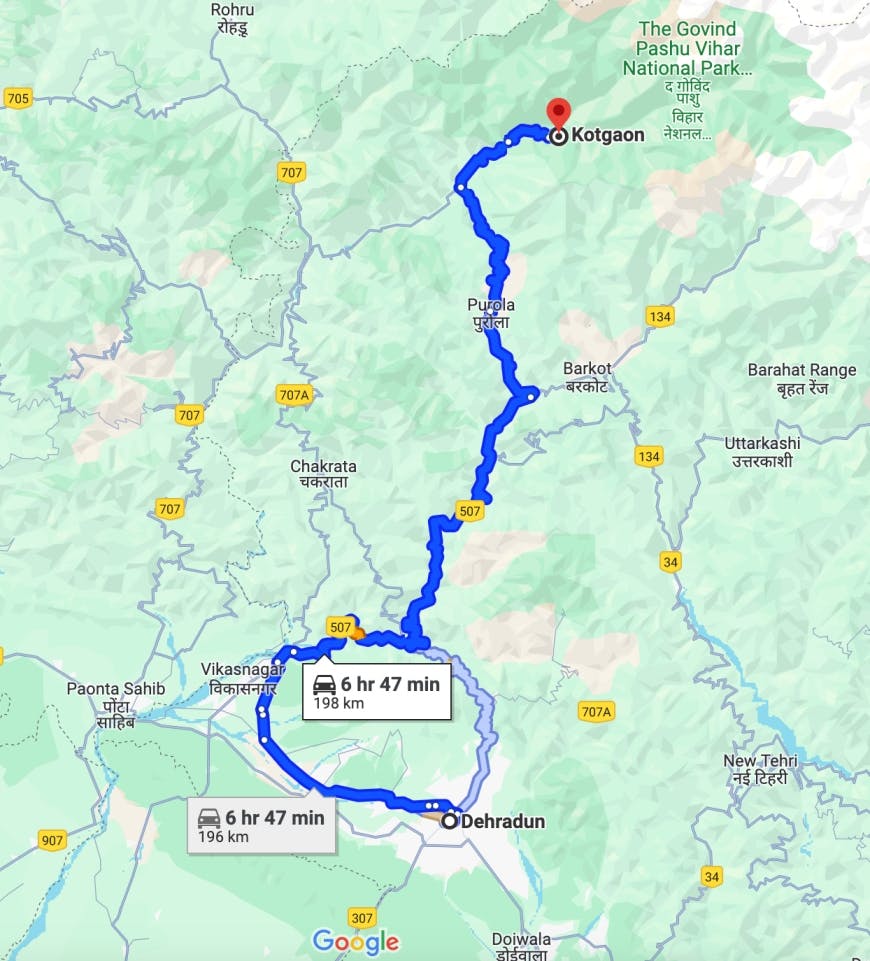
Drive from Dehradun to Kotgaon
Drive Distance: 200 km | Duration: 10-11 hours | Pick up point for Indiahikes trekkers: Grand Legacy Hotel, near Laal Pul, Dehradun or Library Chowk, Mussourie | Pick up Time: 6.30 am | Location of Indiahikes basecamp: Kotgaon
Transport will be arranged at 6.30 AM. The cab can also pick you up from Library Chowk, Mall Road, Mussoorie at 7.30 AM. This cost has to be borne by trekkers and paid directly to the driver. Cost of the cab – Rs 6,500 per vehicle for an SUV, shared among 5-6 trekkers, or Rs 10,000 per vehicle for a Tempo Traveller, shared among 11-12 trekkers.
Day 2
Trek from Kotgaon to Khujaai
Trek Distance: 5.3 km | Trek Duration: 5 hours | Altitude Gain: 6,400 ft to 9,460 ft
Day 3
Trek from Khujaai to Bhoja Dhadi
Trek Distance: 3 km | Trek Duration: 3.5 hours | Altitude Gain: 9,460 ft to 10,700 ft
Day 4
Trek from Bhoja Dhadi to Khujaai via Kedarkantha Summit
Trek Distance: 9 km | Trek Duration: 7-8 hours | Altitude Gain: 10,700 ft to 9,460 ft via 12,500 ft
Day 5
Trek from Khujaai to Kotgaon
Trek Distance: 5.3 km | Trek Duration: 4-5 hours | Altitude Loss: 9,460 ft ft to 6,400 ft
Day 6
Drive back from Kotgaon to Dehradun
Drive Distance: 200 km | Drive Duration: 10-11 hours | Drop off point for Indiahikes trekkers: Grand Legacy (near Laal Pull) Hotel, Dehradun
This transport cost has to be borne by trekkers and paid directly to the driver. Cost of the cab – Rs 6,500 per vehicle for an SUV, shared among 5-6 trekkers, or Rs 10,000 per vehicle for a Tempo Traveler, shared among 11-12 trekkers.
Please note: The distance between campsites may vary by 100 meters depending the weather conditions and the route you take. The altitude may also vary by 100 feet for similar reasons.
IMPORTANT POINTS
➤Documents required: It is mandatory for trekkers to carry a copy of their photo id and medical certificate for entry at forest check posts on the trek. The medical certificate along with the disclaimer form will be part of the Safety Check-in done by the trek leader when you arrive at the base camp.
➤Stay facility: At the base camp, your stay will be arranged in lodges. Do not bring any packaged food, tags from your new clothes or any waste with you. We follow a Dustbin Free Zone and No Wet Wipes Policy at our base camps in line with our spirit of Green Trails.
- On the trek, you will be staying 2 in a tent.
➤Cloakroom facility for excess luggage: We have a Cloak Room facility at the base camp for excess luggage. Every trekker is permitted to leave behind one piece of luggage at no charge. Anything beyond one piece of luggage is chargeable at Rs 500 per luggage. (The luggage could be a backpack/suitcase/duffel bag or anything similar.). Do not leave behind any valuables in the cloakroom.
DAY 1
Drive from Dehradun to Gaichawan Gaon
Drive Distance: 195 km | Drive Duration: 10-11 hours | Pick up point for Indiahikes trekkers: Grand Legacy (near Laal Pull) Hotel, Dehradun | Pick up Time: 6.30 am
Transport will be arranged at 6.30 AM. The cab can also pick you up from Library Chowk, Mall Road, Mussoorie at 7.30 AM. This cost has to be borne by trekkers and paid directly to the driver. Cost of the cab – Rs 6,500 per vehicle for an SUV, shared among 5-6 trekkers, or Rs 10,000 per vehicle for a Tempo Traveller, shared among 11-12 trekkers.
DAY 2
Trek from Gaichawan Gaon to Julota
Trek Distance: 5.5 km | Trek Duration: 4-5 hours | Altitude Gain: 5,600 ft to 8,950 ft
DAY 3
Trek from Julota to Pukhrola
Trek Distance: 3 km | Trek Duration: 3-4 hours | Altitude Gain: 8,950 ft to 10,800 ft
DAY 4
Trek from Pukhrola to Akhoti Thach via Kedarkantha Summit
Trek Distance: 8 km | Trek Duration: 6-7 hours | Altitude Gain: 10,800 ft to 9,170 ft via 12,500 ft
DAY 5
Trek from Akhoti Thach to Gaichawan Gaon
Trek Distance: 7.2 km | Trek Duration: 5-6 hours | Altitude Loss: 9,170 ft to 5,600 ft
DAY 6
Drive back from Gaichawan Gaon to Dehradun
Drive Distance: 195 km | Drive Duration: 10-11 hours | Drop off point for Indiahikes trekkers: Grand Legacy (near Laal Pull) Hotel, Dehradun | Drop off Time: 7 pm
This transport cost has to be borne by trekkers and paid directly to the driver. Cost of the cab – Rs 6,500 per vehicle for an SUV, shared among 5-6 trekkers, or Rs 10,000 per vehicle for a Tempo Traveler, shared among 11-12 trekkers.
Please note: The distance between campsites may vary by 100 meters depending the weather conditions and the route you take. The altitude may also vary by 100 feet for similar reasons.

Day 1 (Pick-up Day): Drive from Dehradun to Kotgaon

Drive Duration: 10-11 hours | Drive Distance: 185 km

Altitude: 6,520 ft
The trek begins at Kotgaon. The journey takes you past Mori and Purola. You see beautiful valleys and forest cover throughout the journey.
At the Naitwar Barrier, you need to take permission. A government-issued ID is essential for this. Take the road that goes straight towards Sankri. Take a right turn in about 30 minutes.
This takes you to Kotgaon surrounded by small hamlets called Shialdi, Paisar, Guradi, Suchan Gaon, Dargar Gaon and Dewara. The guest house where you will be staying is in Shialdi.
Roam around this quaint village and be enchanted by the sound of the Tons river.
Day 2: Trek from Kotgaon to Khujaai

Trek Duration: 5 hours | Trek Distance: 5.5 km

Altitude Gain: ⇗ 2,940 ft (6,520 ft to 9,460 ft)

Difficulty: Easy-Moderate. Gradual ascent in the forest till Mohlani meadows. A combination of ascents and descent to Khujaai

Highlights: Mohlani meadow. It’s a huge clearing with a grand view of the surroundings.
The trek starts from Kotgaon. Start off from the road that goes towards right from the Kotgaon campus. About a kilometre of walk on the road leads to a small suspension bridge. Watch out for the beautiful views of the valley on your left. Just before the suspension bridge, the trail deviates towards the right. Take this trail.
Now, you enter the dense forest. This is a beautiful section predominantly of oak trees. Gradually ascend in the dense jungle for about an hour. You come across a small clearing surrounded by bushes and trees. This is your first resting point.
The forest section continues. It’s a bit of an ascent from here. Savor every bit of it. Listen to the sound of the wind, chirping birds and the rustling of leaves. In another hour, you reach Mohlani meadows. This is a huge clearing and opens up on one side to the grand views of the hills. It is surrounded by tall pine trees on other sides. There is a small Matrishakti Mandir. There is a water source too. Replenish your water supplies here.
Continue in the forest section again for half an hour to reach another small clearing. From here, it’s a bit of a descent. Listen to the sounds of the gushing water stream. Within a few minutes, you come across a small wooden bridge. Cross the bridge and start ascending. About 15-20 minutes of gradual ascent from here takes you to the Khujaai campsite.
The Khujaai campsite is a huge clearing in the middle of dense forest. This is where you spend the rest of the day. Explore around a bit. To your right, you can see the next day’s trail. To your left, there is a cattle space and shepherds’ huts. A little ahead from this is a space where there are a lot of boulders. You can sit and enjoy the view from here. If the weather permits, do not miss out on views of the starlit sky at night.
Day 3: Trek from Khujaai to Bhoja Dhadi

Trek Duration: 3.5 hours | Trek Distance: 3.5 km

Altitude Gain: ⇗ 1,280 ft (9,460 ft to 10,740 ft)

Difficulty: Easy. A combination of ascents and descents in the forest and meadows.

Highlights: Stunning sunset views from Bhoja Dhadi
Start the trek from the trail that goes to the right in the south-west direction from Khujaai. About a kilometre of an ascent in the forest section takes you to Tatalona meadows. It’s a beautiful clearing. Rest here for sometime.
From the meadows, about 600 metres of a descent takes you to a water stream. The gushing stream, the boulders and all of this in the middle of a dense forest makes it a beautiful setting.
Cross this stream. The trail further is again an ascent in the forest section. It can get slippery when it rains. So be mindful of your footing. In about 20 minutes you will reach another small clearing.
Take a steep right turn here. The trail now is through boulders. About another 100 metres of a descent takes you to another water stream. Cross this stream and start your final ascent to Dhoka. It’s another 700 metres of an ascent in the forest section.
Dhoka in Garhwali means “meadow with a big boulder”. Aptly, it is a huge meadow with one big boulder at one end. From here onwards, snow-clad mountains start making their appearance.
A little ahead of Dhoka is Bhoja Dhadi, where you stay for the night. Do not miss the alpen glow on these peaks during sunset. You can also see Kedarkantha summit up ahead of you.
Take a good rest as tomorrow will be a long day.
Day 4: Trek from Bhoja Dhadi to Khujaai via Kedarkantha Summit

Trek Duration: 7-8 hours | Trek Distance: 9 km

Altitude Gain and Loss: ⇗ 1,760 ft ⇘ 3,040 ft (10,740 ft to 9,460 ft via 12,500 ft)

Difficulty: Moderate. 2-3 hour steep ascent to reach the summit. Steep descent to Khujaai

Highlights: Stunning views of the Himalayan ranges from the summit.
There is a trail on the right of Bhoja Dhadi campsite. Start ascending on this trail. Soon, you will reach a section of beautiful rhododendron trees. Meander your way through them to reach a clearing in about 500 metres.
Now you are almost out of the treeline. Continue ascending on a grassy trail. The trail slowly transitions from grassy to muddy. Be cautious as it could get slippery. Ascend in a zigzag manner.
You will soon reach a point where the trail from Sankri joins. It’s a steep ascent from here onwards to all the way up to the summit. You see the Phulara ridge on your left from here. It takes around 2.5-3 hours to reach the summit from Bhoja Dhadi.
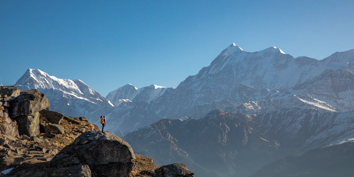
Once you are at the summit, you’re surrounded by the mountain ranges and valleys. You see the Rupin and Har ki Dun valleys. You see Mt Swargarohini, Mt Bandarpoonch and Mt Kalanag predominantly. You see Jaonli, Gangotri, Draupadi Ka Danda and Jorkanden peaks at a distance.
After spending some time at the summit, retrace your way back to Dhoka and further to Khujaai.
Day 5: Trek from Khujaai to Kotgaon

Trek Duration: 5 hours | Trek Distance: 5.3 km

Altitude Loss: ⇘2,940 ft (9,460 ft to 6,520 ft)

Difficulty: Easy-Moderate. A gradual descent through a narrow forest trail.

Highlights: Lovely dense oak forest
From Khujaai, you find a trail going further down. It’s a descent all the way to the Kotgaon.
It’s a narrow trail in the dense forest section, consisting predominantly of oak trees. Savour the forest walk for one last time, as today is the last day of your trek.
Retrace the way back to Kotagon from here and stay at the Indiahikes Community Campus for the day.
Day 6: Drive from Kotgaon to Dehradun

Duration: 9-10 hours | Drive Distance: 185 km
Start early in the morning, preferably before 7.00 AM since the journey takes at least 10 hours. Plan your travel from Dehradun post 7.00 PM on this day.
Start early in the morning, preferably before 7.00 AM since the journey takes at least 10 hours. Plan your travel from Dehradun post 7.00 PM on this day.
Day 1 (Pick-up Day): Drive from Dehradun to Gaichawan
Drive Duration: 10-11 hours | Drive Distance: 200 km | Altitude: 5,570 ft
The trek begins at Gaichawan Gaon. The journey takes you past Mori and Purola. You see beautiful valleys and forest cover throughout the journey.
At the Naitwar Barrier, you need to take permission. A government-issued ID is essential for this. After the barrier, take a right turn to go to Gainchawan Gaon. The road that goes straight takes you to Sankri. After taking the right turn, take another right turn in about 30 minutes.
Roam around this quaint village and be enchanted by the sound of the Tons river.
Gaichawan Gaon is known as the Apple Valley of this district of Mori. You will see apples being grown in this region.
One can see a strong influence of Kathkuni Architecture which has come from Himachal Pradesh. The houses are built using an interlocking mechanism of rocks and wood. An alternate lego block of this sustainable way of building houses without using cement is something very rare and remote to witness.
Our homestay at Gaichawan Gaon is a cultural hotspot. The storage is almost a hundred years old in the basecamp. You will be able to see the Kothar here, which is the grain bank. You have underground levels. Under that, there is another floor section to keep ration. The residents of the house store their ration in it. It is generally two storey and a little elevated from the ground. It has a very small entrance and inside you’ll find four compartments dedicated to different grains and the upper storey is used to store dry meat etc. for the winters.
Day 2: Trek from Gaichawan to Julota
Trek Duration: 5.5 hours | Trek Distance: 5.2 km | Altitude Gain: ⇗ 3,350 ft (5,570 ft to 8,920 ft)
Difficulty: Moderate. Gradual ascent for 2 to 2.5 hours followed by a steep ascent
Highlights: Unique culture and architecture at Haltwar. Lovely pine and oak forests to enter into clearings.
There’s a motorable road to Haltwar which is a work in progress. From Gaichawan Gaon, you will have to stick to the villager’s path that goes through apple orchards and farmlands. The Suchan Gaon and Dargar Gaon villages are unique in their culture, in their architecture and lifestyle. Haltwar is at a distance of 3 km from Gaichawan Gaon if you come through these villages and 6 km via the motorable road.
Haltwar is a small village with few houses. While spotting a building with Kath-Khuni architecture, do notice the waste hotspot around the village where you can leave the mountains better.
You get beautiful views of the Rupin Valley from here. Experience local cuisine such as siddu in one of Dhabas in Haltwar. Kamlesh Ji’s dhaba is a no packaged food dhaba.
From Haltwar, the trail first goes inside a light forest that ascends gradually. In some time, you see a beautiful clearing amidst pines and oaks. Soon you see a wooden bridge over a stream bed. There’s a water source here to refill your water bottles.
After the clearing, you enter a dense forest of pine and oak. The trail from here on gets gradually steeper and more like a staircase made of slabs of rock. After gaining some altitude, the incline becomes more gradual.
This place is a magical experience when you trek while observing the silence with birds chipring around you. Dont forget to get immersed in this rich ecosystem as a few maple trees and Rohdodendrons start popping sparsely in the forest.
Follow the trail through the forest until you reach another lovely clearing. This second clearing indicates about you getting closer to the campsite of Julota.
From here it is a gradual ascent until you start noticing few dome shaped tents to reach a stunning clearing where you get to witness a beautiful sunset. This is your Julota campsite.
Day 3: Trek from Julota to Pukhrola
Trek Duration: 3.5 hours | Trek Distance: 3.50 km | Altitude Gain: ⇗ 1,950 ft (8,920 ft to 10,870 ft)
Difficulty: Easy. Half a kilometre ascent to a meadow followed by half a kilometre of a level walk. Gradual ascent which becomes steep for the last 300 meters to Pukhrola.
Highlights: A moderate climb through forests and clearings followed by a rewarding sunset
Today’s trek is quite short but there’s close to 2,000 ft of altitude gain through a couple of bigger clearings. So remember to keep yourself hydrated well. The trail is steeper and the terrain is undulated and mixed.
The trek starts with passing through some charming golden oaks. The fallen wooden log with moss and smaller being living transports you to another world.
Within 400 metres of Julota, you reach a clearing. Pass this clearing and walk for another 400 metres to reach the next clearing. This is called Shiun Ka Thatch.
The trail again goes through a thick forest section of Oaks and opens into a much bigger clearing called Moru Ka Thatch. You will see a dhaba near the end of the clearing where you can try the local dishes of Siddu, Sidku or Pua. Take a short break here to enjoy the serenity of the place.
After Moru Ka Thatch, you trek through a tree-covered area on steep terrain. The tree cover slowly loses density and you see Rhododendron and drawf rhododendron trees. You will cross a few streams on the trail. It is colorful in Spring and snowy capped in Winter making it a perfect forest to spend time in.
In 45 minutes to an hour, you reach an amphitheatre-like setting. You can see a lot of mountain ridges from this meadow. This is Pukhrola, our new base in Kedarkantha. You can also see the Kedarkantha summit up ahead of you.
Take a good rest and enjoy the picturesque sunset here. Do not miss the night sky with billions of stars above you.
Note: The cold in the open is intense and it often gets windy. Ensure you layer up once you reach the campsite to trap the heat after your trek.
Day 4: Trek from Julota to Akhoti Thatch via Kedarkantha Summit
Trek Duration: 7-8 hours | Trek Distance: 9 km | Altitude Gain and Loss: ⇗ 1,630 ft ⇘ 4,230 ft (10,870 ft to 8,270 ft via 12,500 ft)
Difficulty: Easy to moderate. 2-3 hour steep ascent to reach the summit. Steep descent to Akhoti Thatch.
Highlights: Stunning views of the Himalayan ranges from the summit.
Today you make the final push towards the summit. Start from Pukhrola at 4.00 AM.
The route goes on the western ridge of the mountain and it gets steep at multiple points. Climb in a zigzag way in such places. It takes 2-3 hours to reach the summit by this route. On the summit, you are surrounded by mountain ranges and valleys.
You see the Chainsheel Pass, Rupin valley, and Har Ki Dun Valley. Mt Swargarohini also comes into view along with Mt Bandarpoonch and Mt Kalanag. Some of the other peaks you see include Jaonli, Gangotri, Draupadi Ka Danda and Jorkanden.
After spending some time on the summit, retrace your way to Pukhrola. Reach Pukhrola by lunchtime. Have lunch and trek down to Akhoti Thatch.
Akhoti Thatch campsite is 2 km from Pukhrola. It will take 2.5-3 hours to complete this stretch through the forest section. A slight deviation from the trail towards Pukhrola takes you on the trail towards Akhoti Thatch. This campsite is a nice big clearing amidst walnut trees and hence the name.
Day 5: Trek from Akhoti Thatch to Gaichawan
Trek Duration: 4-5 hours | Trek Distance: 4 km | Altitude Loss: ⇘ 2,700 ft (8,270 ft to 5,570 ft)
Difficulty: Easy. Gradual descent all the way.
Highlights: Beautiful Oak and Rhododendron forests. View of Kedarkantha Peak from afar.
After breakfast, start moving towards Gaichawan. This is 6 km from Akhoti Thatch. The trail after Akhoti Thatch and till reaching Haltwar is untouched and serene.
The trail goes through thick Oak and Rhododendron forests. There are a few small clearings and river streams while on the way down. The trail is not that well-made because not too many trekkers come here.
After 2 hours and almost 2 km of descent from Akhoti Thatch, we reach an opening with shepherd huts. Take a small break here before starting your next phase of the descent.
This next section is a thrilling experience for trekkers to cross. You have a small waterfall which needs to be traversed carefully. There is space for only one trekker to navigate on the trail here. If you are lucky, you can catch glimpses of Martins and red foxes in the early morning.
The route descends further towards Haltwar, which is one and a half hours away. While on the way to Haltwar, you can see Gaichawan Gaon from a small opening in the forest. It takes another 1.5 hours to reach Gaichawan Gaon as you end your memorable experience of trekking to Kedarkantha.
Day 6: Drive from Gaichawan Gaon back to Dehradun
Drive Duration: 10-11 hours | Drive Distance: 200 km
Start early in the morning, preferably before 7.00 AM since the journey takes at least 10 hours. Plan your travel from Dehradun post 7.00 PM on this day.

Easy-Moderate
Suitable for Beginners
At Indiahikes, while rating a trek difficulty we consider a number of factors. These include, altitude gained every day, length of trek everyday, highest altitude, nature of the terrain, weather etc. Based on this, we rate a trek as easy or difficult or somewhere in between.
Kedarkantha is categorized as an easy-moderate trek. At Indiahikes, we classify a trek as easy-moderate if it fits the following criteria:
- The ascent is gradual and evened out
- The trek is 5-6 days long
- The altitude reached is within 14,000 ft
- The trek has easy and multiple exit points
Kedarkantha fits all of these criteria very well. In Kedarkantha, you climb an altitude of 5,500-6,000 ft within 3 days. The ascent is gradual and steady. Of course, there are certain steep sections spread out, but when well-prepared, they are easy to tackle.
Also, every day of the trek, you climb for a maximum of 4 hours (except on the summit day which in general tends to be longer).
Next, the trek reaches a maximum altitude of 12,500 ft. Hence, it is extremely well-suited for beginners and trekkers who are looking to not do a demanding trek.
Last, as mentioned earlier, Kedarkantha is a stand-alone mountain. Hence the trek presents multiple routes to the summit. The biggest asset is that these routes provide multiple exit routes making it an ideal trek in terms of safety. This is especially important when you are looking to trek on your own.
What raises the difficulty level to easy-moderate?
Although this trek has all the components of an easy trek, the aspect of Kedarkantha which makes it an easy-moderate trek is its summit climb. The summit climb is long and steep.
Not just that, the duration of the summit day is also quite long. You are looking at about 7-8 hours of the trek on the summit day with about 5 hours of steady climb and 2-3 hours of fast descent. This is challenging on the legs and you need a good level of fitness to comfortably finish this day.
Considering all of this, the trek has been marked as easy-moderate.
Safety on the Kedarkantha Trek
When it comes to terrain, Kedarkantha can be considered as highly safe. The entire route is marked with:
- Well marked trails
- Well trodden routes
- Gradual ascents
- Well placed campsites (important when considering AMS)
- Easy and multiple exit points
There are hardly sections that are challenging and require technical assistance. The only tricky section is the ridge walk closer to the summit. However, even this section does not require technical assistance.
In this trek, you are climbing around 6,300 ft in the first three days and reaching a maximum altitude of 12,500 ft. Naturally, you can get hit with AMS.
Few aspects of the trek that helps mitigate AMS:
- The campsites are placed well within a normal altitude gain for each day. With a steady pace, the chances of getting AMS are less.
- The second day is shorter in length and altitude gain. This gives you ample opportunity to rest and acclimatize before the long summit day.
- On the third day, you lose a lot of height. This helps recover from most AMS symptoms that might occur on the summit day.
However, there are still chances of getting hit by AMS.
In this trek, the symptoms can start right from day 1. Most trekkers present with the starting symptoms of AMS – usually headache or tiredness mixed with perhaps lack of appetite or sleep. The immediate step to take would be to start on a curative course of Diamox which is 250 mg, every 12 hours followed by ample rest.
The earlier you treat these symptoms, the higher the chances of recovering and completing the trek.
If you present with symptoms that persist for more than 12 hours, descend to the base camp.
As you climb higher and proceed beyond 11,000 ft, there are chances of HAPE/ HACE to occur as well. In our history of running this trek, we have never had a trekker present with HAPE/HACE. Nevertheless, it is better to be prepared and mindful of the symptoms. Read and learn more about HAPE/HACE and how to tackle it here.
Here’s a Complete Guide to Acute Mountains Sickness, HAPE and HACE:
The trek is safe for all the ten months of the year it is open. The trek can get slippery and tricky when there is a lot of snow. However, this can be managed with the right gear – microspikes, gaiters, etc.
The trek also gets extremely cold in the winter and can result in cold-related injuries. But this can be tackled with the right winter gear, right technique of layering and good insulation techniques.
Emergency Exits: Kedarkantha is one trek that has multiple routes and thereby multiple exit points to safety. You can follow them easily on the map below.
You can exit the trek from Sankri, Kotgaon or Gaichawan Gaon. In case of an emergency, the closest exit point to the hospital would be Kotgaon. It is also the nearest road head when compared to the other exit points of the trek.
Note: As you can see, the three trails in Kedarkantha are interconnected. There are multiple bridging routes in between to move from one route to the other within the trek. However, this requires extensive knowledge of the trails to navigate. So, we strongly recommend against switching a route unless you are with a team who knows the trek like the back of their hand.
Closest Hospitals: For mild medical issues, the closest medical assistance can be found in Mori and then in Purola. This includes simple fracture, sprain, etc.
1. Mori
Government Hospital
Mori – Sankari Rd, Mautar, Uttarakhand – 249128
Primary Health Center
Mori, Uttarakhand – 249128
Ph: 01373 234 486
2. Barkot
Government Hospital
Barkot, Uttarakhand – 249141
Swami Vivekanand Dharmarth Chikitsalay
Barkot, Uttarakhand – 249141
Ph: 095576 19690
However, for major medical emergencies, the nearest hospital is in Mussoorie or Dehradun – which is almost 8-9 hours away from the base camp of the trek.
Kedarkantha trek is one of the few treks in the Indian Himalayas where you can trek for the most part of the year. Kedarkantha trek is accessible for 10 months of the year except for July and August (the peak rainy months in Uttarakhand).
The 10 months cover four different seasons –
Winter – December to February
Spring – March and April
Summer – May and June
Autumn – Mid September to November
Each of these seasons has something very different to offer in terms of terrain, difficulty and weather.
Kedarkantha in Winter (December, January and February)
 Day time: Between 8 °C and 10 °C | Night time: Will drop to temperatures between 0 °C and -10 °C.
 Presence of snow: You will find snow from the base camp towards the end of December. The entire landscape and valley will be in white.
 No. of warm layers required: 5 warm layers.
Kedarkantha is most popular as a winter trek and it is rightly so. The beautiful snow-covered landscape and an adventurous summit climb especially in the winter can make anyone go weak in the knees. It was discovered, documented and brought out to Indian trekking by Indiahikes as a winter trek.
Kedarkantha is a perfect winter trek – especially for beginners. What makes it perfect is how it brings about beauty and adventure together in the right proportion. You get to trek through dense forests that are covered with snow. You will learn to camp in clearings on thick mounds of snow.
The summit climb will get your adrenaline kicking with the thick blanket of snow to the summit. These make the trek in winter a memorable and a unique experience even for experienced trekkers.
Note: Kedarkantha trek gets extremely crowded from the Sankri side starting December 15th until mid-January. It is at this time, you will appreciate the more quiet and pristine Gaichawan Gaon route which Indiahikes trekkers go on.
Read Vikash Lavaniya's Blog on Kedarkantha - 7 Lessons My First Winter Trek Taught
Kedarkantha in Spring (March and April)
 Day time: Between 15 °C and 18 °C | Night time: Will drop to temperatures between 0 °C and 5 °C.
 Great time to experience the last of the winter snow. The snow starts to recede from the lower campsites when spring sets. The upper reaches of Kedarkantha are still under snow.
 No. of warm layers required: 3 warm layers.
Kedarkantha in March still carries quite a bit of snow – especially the higher campsites towards the summit. What you will also see are the Rhododendrons and the freshly exposed grasslands blooming. This is a sight to watch especially when you see the flush of colours in contrast against the snow backdrop as you climb higher.
Snow melts away by April in Kedarkantha. Kedarkantha in April is a must to experience the beautiful landscape come alive after its long winter hibernation. The weather is much more pleasant to trek and camp in and the spring is in full force during this month. There is a riot of colours all along the way.
Kedarkantha in Summer (May and June)
 Day time: Between 18 °C and 24 °C | Night time: Will drop to temperatures between 3 °C and 8 °C.
 Presence of snow: You will not find any snow in the summer season.
 No. of warm layers required: 2 warm layers.
Kedarkantha in May is marked with bright sun in the morning. In the evenings, the cold is not as harsh as in the other months.
Kedarkantha in June has occasional rainfall. Monsoon sets in only in July. The entire trek turns lush green.
In May and June, crowds are less as most of them are now moving towards the higher altitude treks. All in all, a great time to trek if you are looking to enjoy the trek in more isolation.
Kedarkantha in Autumn (September, October and November)
 Day time: Between 10 °C and 15 °C | Night time: Will drop to temperatures between 0 °C and -5 °C.
 Presence of snow: You will not find any snow in the autumn season.
 No. of warm layers required: 4 warm layers.
Right after the monsoon, the entire trek comes alive in September. The meadows and the forests are fresh and alive during September and continue to be so in October as well. The air is crisp and the views of the upper Himalayas are strikingly clear.
The trek does get cold as we proceed towards November. And the feeling of incoming winter sets in during November. The views and the terrain remains crisp and beautiful for the trekker.
All in all, the ten months are ideal for anyone to do the trek.
Planning your onward flight/train booking
If you are travelling from Bengaluru, Chennai, Pune, Mumbai or any other city, book your air tickets for Day Zero, which is the day before Day 1 on the itinerary. If your trek start day is 25 August, book your air tickets for 24 August to either Delhi/Dehradun.
There are two options.
Option 1: Fly directly to Dehradun
We recommend this. It gives you an added rest day at Dehradun. Most metros are directly connected to Dehradun. However, if the cost of the flight ticket to Dehradun is too high, book to Delhi and connect to Dehradun by train/bus.
Tip: Train is the best option to get to Dehradun. Bus journeys are often delayed by a few hours.
Taxis are available from the airport (plenty). Prepaid taxis are available (look for the pre-paid taxi counter just out of the conveyor belt at the arrivals). You can also flag down a taxi (bargain a bit) with taxis outside the airport. Airport taxis are exorbitant. They usually charge between Rs 800 to Rs 1,000 to Dehradun.
Usually, most passengers take taxis from the airport. Try to hook up with co-passengers on the flight for your taxi ride to Dehradun.
Pro Tip: If you want to save real money try to catch an auto just outside the airport terminal complex. They usually come there to drop passengers off. Autos are not allowed to enter the airport complex. They charge approximately Rs 300 to Dehradun.
If autos are not available, walk for a further 1.5 km to get to the Rishikesh Dehradun highway. From the highway, you can flag down regular town buses or shared autos (shared autos are called Vikram's). Bus fare is about Rs 30 to Dehradun. Shared autos charge about Rs 20.
Option 2: Flying to Delhi/Dehradun
Flying to Delhi may be a lot cheaper than getting to Dehradun. Make sure to book a flight that reaches Delhi by 8.00 pm. You must arrive in Delhi on Day Zero and not on Day 1.
Note: If you notice the difference in air ticket prices between Delhi and Dehradun is less than Rs 1000 then book directly to Dehradun. The rest and shorter travel time are worth the difference.
Next, book yourself on the Nanda Devi Express to Dehradun (Train No: 12401). It is a fully AC train that leaves at 23.35 hrs from Hazrat Nizamuddin and gets to Dehradun at 5.40 am.
Note: Earlier the Nanda Devi express would depart from New Delhi railway station. From 26 Aug 2019, it leaves from Hazrat Nizamuddin railway station. The train now comes from Kota. So expect about 15 to 30 mins delay in arrival. The train number has changed too from 12206 to 12401.
At Hotel Grand Legacy (near Laal Pull), Dehradun/Library Chowk, Mussourie, wait for Indiahikes pick up at 6.30 am/7.30 am. Contact your driver by 6.00 am. The number of your transport coordinator will be shared with you a day or two before your departure.
Caution: Do not book on any other train except the Nanda Devi Express. The other option, Mussoorie express, is notorious for its delay. Your pickup vehicle may leave without you. If you do not get tickets on the Nanda Devi Express, take a bus from Delhi to Haridwar, but do not book on the Mussoorie express.
Pro Tip: Take the afternoon Jan Shatabdi express from New Delhi railway station (leaves at 3.20 pm) to arrive at Dehradun by 21:10 in the night. Stay overnight at Dehradun. Take the Indiahikes to pick up the next morning directly from Hotel Grand Legacy (near Laal Pull), Dehradun/Library Chowk, Mussourie.
Bus: If in case you do not get a train ticket, there are regular Volvo AC buses from Delhi’s ISBT Kashmiri Gate to Dehradun. You also get Non-AC buses. Buses are frequent and not usually crowded. You can get a bus almost every half hour. Buses take 7-8 hours to get to Dehradun from Delhi. AC bus tickets cost about Rs 700.
Note: The last metro line from airport to New Delhi to reach Kashmiri gate is 23:15. It costs you Rs 60.
Planning your return flight/train booking
Booking your return tickets requires some thought. First, keep some buffer time in mind before booking tickets. If you are scheduled to reach Dehradun around 6.30 pm, book your onward bus or train tickets only after 9 pm. In case you are stuck in traffic or get delayed at your lunch spot, you will have some buffer time to catch your bus/train.
Next, if your onward flight departs from Delhi/Dehradun, then book flight tickets for Day 7.
Sometimes trekkers worry if they can book an early morning flight out of Delhi on Day 7. Yes, you can. But book flights that depart only after 8 am. Do not book any flight between 6.00 and 8 am. You may not reach Delhi in time.
How to get to Delhi on time for an early morning flight.
If your flight is early, say between 8.00 and 9.00 am, then there are two options.
Train: Take the Nanda Devi Express from Dehradun (12402) that leaves at 22:40 hrs to get to Hazrat Nizamuddin Railway Station at 04:50 in the morning. From Hazrat Nizamuddin, you get airport buses from outside the station as well as taxis. The Metro train is somewhat inconvenient from Hazrat Nizamuddin.
Note: Earlier Nanda Devi express would arrive at the New Delhi railway station. From 26 August 2019, it has been extended up to Kota. It no longer goes to the New Delhi railway station. Instead, it goes to Hazrat Nizamuddin railway station. The train number has changed from 12206 to 12402.
Bus: The other option is to take a bus from Dehradun. It is about a 6½ – 7 hrs journey to Delhi. So if you take a bus that leaves around 9.00 pm, then expect to reach Delhi at around 04.00 am (ISBT Kashmiri Gate). A bus that leaves at 10:00 pm will reach Delhi around 05.00 am. AC Volvo buses are the fastest, so opt for them. Non AC buses can take up to 7-8 hrs for the journey.
From Kashmiri Gate ISBT you get Airport buses or taxis.
Note: Metro trains in Delhi do not start before 5.00 am.
If you are taking a flight out of Dehradun
If you are taking a flight out of Dehradun then book yourself on Day 7. Most metros are now well connected by Dehradun by flight.
Planning your hotel/stay
In Dehradun, look for hotels around your pick up point. There are quite a few options available online and it is not difficult to find last-minute hotel bookings.
Hotel options at Dehradun
1. Hotel Grand Legacy is where your pick up is. It's a nice option. It has clean rooms with good amneties. Rooms ranges from Rs 1,800 onwards depending on the booking website.
Location: https://goo.gl/maps/tcbToJs1qnu3JP349
Phone: +91-9358774612
2. Nomads House is another new backpacker hostel in Dehradun. The atmosphere is good. The place is neat and clean. Indiahikes trek leaders love Nomads House. It is about 10 mins from the Dehradun railway station. Bunk beds start at Rs 400, rooms start at Rs 800. Shared autos are easily available to get to Nomads House.
Location: https://g.page/NomadsHouse?share
Phone: +91-9760596464
3. Hotel Drona, which is a government property owned by the GMVN is decent. It is an old, but large and spacious property. It is about 1.5 km from Dehradun railway station. Rooms start at Rs 750.
Phone: +91-9568006631
Book online https://gmvnonline.com/room-tariff.php?trhID=9&adults=&child=&checkindate=&checkoutdate=
Location: https://goo.gl/maps/sjWSkGhe5LfAN8wDA
4. Simran Guest house is another option near Grand Legacy. It has very basic amneties with rooms starting from Rs 700 onwards.
Location: https://g.page/simran-guest-house?share
Phone: +91 - 9219882447
Hotel options near Jolly Grant Airport
1. Sun n Soil Backpackers hostel is a great option, if you want to stay near Jolly Grant airport. It's a great place for the backpackers and travellers as it has a different ambience. Bunk beds start at Rs 450, rooms start at Rs 1,000.
Location: https://g.page/sun-n-soil-backpacker-hostel?share
Phone: +91 - 9634570743
What if you miss the Indiahikes pickup?
Getting to Kotgaon on your own
If you miss the Indiahikes pick-up from Dehradun, here is how you can get to Kotgaon base camp on your own.
Bus from Dehradun to Sankri
There is a direct bus from Dehradun Railway Station to Jakhol. It leaves at 7 am. The cost per ticket is Rs 400/-. Get down at Motwar. Kotgaon is about 3 km away from Motwar and is not on the same route as Sankri. Take a shared taxi from Motwar to Kotgaon. There are private buses that leave from outside Dehradun Railway Station 6:30-7:30 AM to Sankri as well.
Alternatively, there is a trekking route from Motwar to Kotgaon base camp. This is a well-marked 1 km long trail but is a steep ascent. It may become difficult if you have more luggage.
If you are reaching Dehradun late, you can take a bus to Purola/Naugaon and then a private cab to Motwar
Tip: While this bus hopping may sound cumbersome, we do it regularly at Indiahikes. They are a fun and a good way to know the real Uttarakhand. You also get to meet very interesting local people. So while no one wants to miss a pickup, don’t be too disheartened if it happens. You may just experience one of your best travel moments!
These are documents required for legal purposes by Indiahikes and the forest department. Without any of these, you will not be allowed to trek.
- Original and photocopy of government photo identity card. Anything such as a driver’s license, Aadhar Card, or passport will do. This is required by the forest department for your identification.
- Disclaimer certificate: There are two sections in this. The first part is a personal medical record. The second part is a legal requirement. Download the PDF, read carefully, fill in and sign it. This must be handed over to your Trek Leader during registration at the base camp. – Download disclaimer certificate
- Medical certificate: The medical certificate needs to be filled out by an MBBS doctor, without which the forest department will not issue permissions for your trek. It is also a requirement by Indiahikes – Download medical certificate
Note: Indiahikes has a panel of doctors who can help you with a medical certificate. They are available for online consultation. To get in touch with them, please write to trekmedicalcertificates@gmail.com. They will respond to you within 24 hours.
Consultation fee: Rs 300
PRO TIPS
Keep important documents in a clear plastic cover and slide them into the inner pocket at the back of your backpack. This keeps them from getting wet.

Before you purchase any gear, make sure you visit the Crosstrek Rental store, where you can get custom-made high quality gear at 5% of the buying cost.
You can rent trekking shoes, backpacks, padded jackets, trekking poles, rainwear and headlamps for less than Rs 1400 for the entire duration of your trek. Visit our Crosstrek Rentals store here.
Here is a list of everything you need for your trek.
Shoes and backpack
- Trekking shoes with ankle support (Available on rent)
- Backpack with rain cover (Available on rent)
Warm Layers and Clothes
- Warm layers (Padded jackets available on rent)
- 3 layers if you're trekking in spring, summer and monsoon (1 woollen sweater, 1 fleece, 1 padded jacket)
- 4 layers if you're trekking in autumn (1 woollen sweater, 2 fleece, 1 padded jacket)
- 5 layers if you're trekking in winter (1 pair of thermals, 1 woollen sweater, 2 fleece, 1 padded jacket) - 3 Collared T-shirts (Wear one, carry two)
- 2 quick-dry trek pants (Wear one, carry one)
Accessories
- Sunglasses (Available on rent)
- Sun cap, preferably with flaps (Available for purchase)
- Waterproof gloves (Available for purchase)
- Balaclava
- Woollen socks (2 pairs of Dry fit + 1 pair of Woollen)
- Headlamp (Available on rent)
- Trekking pole (Available on rent)
- Rain jacket + pants / poncho (Poncho is available on rent)
Toiletries:
- Sunscreen
- Moisturiser
- Light towel
- Lip balm or vaseline
- Toilet paper (Wet wipes are strictly not allowed on our treks)
- Toothbrush
- Toothpaste
- Reusable plastic covers (for used clothes)
Cutlery:
- Steel lunch box, spoon and a coffee mug (Lunch box is available on rent)
- Two water bottles or Hydration Pack (Water bottles are available on rent)
Once you run through this list, don't miss this ultimate guide on what gear to take on a trek. It contains tips on what gear to choose, where to get it from and how much to spend on it.
Our only tip: Keep your backpack light. Indiahikes practices low impact sustainable trekking in every aspect of the trek. Carrying your own personal backpack reduces your impact on the mountains by 20%. We expect all our trekkers to carry their own backpacks unless they have a justifiable reason not to.

Carry these medicines with you, easily accessible at all times. Do not take any medicine unless you have consulted your trek leader.
- Diamox (1 Strip): It is important to carry Diamox as part of the Live Saving Drugs. Read more about Diamox here on how it reduces the chances of Acute Mountain Sickness on the trek.
- Dolo 650 (5 tablets): This is a paracetamol. It helps to tackle fever, mild pain
- Avomine (4 tablets): Carry this especially if you are prone to motion sickness. Pop one-half hour before the start of your road journey.
- Combiflam (5 tablets): Take a combiflam if you get a sudden twist of the leg or a muscle strain. It is a pain reliever. It also contains paracetamol.
- Digene (4 tablets): Take it if you feel the food that you’ve taken is undigested. Alert your trek leader immediately. It could be a sign of AMS.
- ORS (6 packs): Consume a pack of ORS water at least once a day, usually mid-day when you are in the middle of your trek. It replenishes essential salts lost while trekking. Tip: It also makes cold water easier to drink.
- Knee Brace (optional): Carry this if you are prone to knee injury or have known issues of knee pain.
Our trek leaders carry a high altitude medical kit with them which also consist of Life Saving Drugs. If there is an emergency our trek leaders know how to tackle it. Meanwhile, contact your trek leader before consuming any of these medicines listed here.
Pro Tip: We find that these medicines by trekkers are rarely used. But you cannot do away with them. At the end of the trek please donate unused medicines to your trek leader. Some of these medicines get distributed to villages on the trek and some are added to the Indiahikes medical kit.
We recommend jogging as the best routine to get fit for a trek. It works on the same muscles that you use while trekking — your calves, glutes and hamstrings. It helps increase your stamina day by day. It is also an easy routine that does not require any equipment or tools.
Fitness target:
To do this trek comfortably, you must be able to cover 5 km in under 38 minutes. This is the minimum fitness required for this trek.

How to achieve this fitness?
- Start jogging at least 4 days a week
- If you cannot run 5 km immediately, start with 2 km and increase to 5 km over 2-3 weeks.
- Once you’re able to run 5 km, increase your pace day by day.
- Gradually increase your pace and bring it down to 5 km in less than 38 mins.
- You must be able to run 5 km in 38 mins consistently for at least 2 weeks before the trek.
This trek requires at least 6-8 weeks of preparation. The longer, the better. So plan your trek soon and start preparing.
Here's a complete guide to get you trek fit.
Strength training tips:
How to get Fitness Approval from the Indiahikes team:
Every trekker needs fitness approval from the Indiahikes team 20 days before the trek date. Without this, you will not be allowed on the trek.
What to upload?
- A minimum of 3 screenshots of your runs/jogs/walks/cycling
- Monthly summary of your routine
Why fitness matters:
Every high-altitude trek comes with a set of challenges. Steep ascents and descents, uneven terrain, snow walks, stream crossings, pass crossings, and summit climb. Even the easiest of treks have some of these challenges if not all of them. Without fitness, trekkers struggle, get injured easily, lag behind, or simply fail to complete the trek.
At Indiahikes, we take pride in the fact that our trekkers are among the fittest in the country. Those who do not meet the fitness requirements are often sent back. Our philosophy is that trekking and fitness go hand in hand. Without fitness, there’s no trekking.
Kedarkantha Trek is an 18 km long trek that spans over 4 days (6 if you include the travel days from Dehradun and back). On the first day, you trek for about 5 km for about 4 hours. The second day is shorter where you trek for about 2 km over 2 hours.
The third day is the longest day of the trek as you trek to the summit and come back to the next campsite. On this day, you trek about 6 km over 6-7 hours. On the last day, you trek for 5-6 km again over 5 hours.
Kedarkantha trek reaches a maximum altitude/height of 12500 ft. Depending on the starting point, there are three altitudes you start the trek from:
Sankri – 6,455 ft
Kotgaon – 6,520 ft
Gaichawan Gaon – 5,600 ft
From the starting point, the trek climbs a height/altitude of more or less 6,000 ft during the length. You steadily climb up the first three days of the trek till the summit and climb down on the last two days. Please check the short/detailed itinerary to understand the trek in more detail.
Kedarnath and Kedarkantha are not the same. The distance between Kedarkantha and Kedarnath is around 370 km by road. They are a 12-hour-journey away from each other.
Kedarkantha is a Himalayan summit in the Govind Pashu Vihar National Park in Uttarakhand. It is a popular trekking trail that takes trekkers to the top of a summit, from where you see fantastic views of the Garhwal Himalayas. It is known for its beautiful forest trails, pretty campsites and the remote villages on the trail.
Kedarnath, on the other hand, is a revered Hindu temple in Uttarakhand. It is considered one of the 12 most sacred Shiva Temples in the world (the Jyotirlingas). It has enormous religious and mythological significance, attracting pilgrims from all over the world.
Yes you can!
If you are above the age of 58 years, you’ll need to submit a Treadmill Test (not older than 12 months) within a week of completing your trek registration. Apart from this, you should also be able to jog 5 km in 45 minutes.
Network and connectivity are sparse in Kedarkantha. But there are few locations where you can rely on a good network for communication on the trek route.
The last ATM en route to the base camp is in Mori. Mori has an SBI bank with an ATM attached to it. However, the ATM is empty of cash many times. In such a case, you may head out to an SBI authorized cash withdrawal centre. You can swipe your card and get cash from the person servicing the desk. This centre is located on the first floor, two buildings to the right of SBI.
Although Mori has this possibility, we strongly encourage trekkers to bring cash or to withdraw cash from the 3 ATMs available in Purola (SBI, ICICI and Axis Bank ATMs).
Sankri/Gaichawan Gaon/Kotgaon are the last points that are electrically connected. However, the electricity is extremely intermittent and can be absent for most part of the day during winter/late summer (when the monsoon starts to set in).
So, we strongly encourage you to bring additional batteries for your cameras and a power bank with more than 10,000 mAh to last you the entire trek.
Pro Tip: Beware that the power from your batteries will drain faster in cold temperatures of this region. So, put the batteries in a small pouch and keep them inside your sleeping bag to keep them warm during the night.
At Kedarkantha, you have the opportunity to drop your luggage at the base camp for the duration of the trek. Every trekker is permitted to leave behind one piece of luggage at no charge. Anything beyond one piece of luggage is chargeable at Rs 500 per luggage. (The luggage could be a backpack / suitcase / duffel bag or anything similar.).
At the end of the trek, the cloakroom belongings will be brought back to you.
Please do ensure that you do not leave valuables in our cloakroom facility. If you do so, do inform our staff so that they can take the necessary precautions to keep it safe.
Having too many mules on a trail isn’t good for the ecosystem. This is why, at Indiahikes, we do not encourage offloading. A trekker carries his/her own backpack in the true spirit of trekking.
But if — due to a medical condition — you are unable to carry your own backpack, you may offload your backpack.
The cost of offloading on the Kedarkantha trek is Rs 1,680 for the trek.
5 Reasons Why Indiahikes

When we brought out new trails in Indian trekking, safety came with us. Back in 2012, we were the first to introduce microspikes, and two years later, pulse oximeters became standard thanks to us. Nobody does safe treks like Indiahikes. In the mountains, emergencies don't care who you're with – everyone knows that when trouble hits, you look for the yellow tents of Indiahikes.

We are pioneers in trekking. Since 2007, we have brought out treks that have become India's most famous treks: Roopkund, Rupin Pass, Buran Ghati, Kedarkantha, Kashmir Great Lakes, Tarsar Marsar, Brahmatal, Phulara Ridge—the list goes on. In 2023 alone, we brought out five new treks in Indian trekking. We know treks better than anyone. This comes directly from the reason why Indiahikes was born: to bring out trek information and enable trekkers to trek on their own.

More than 25,000 people trek with us every year. We are the largest trekking organisation in India. 24% of our trekkers come back to trek with us every year. Over 4,000 students from the top educational institutions trek with us every year. Aside from this, families with children choose to trek with Indiahikes knowing that our treks are the safest. We have taken over 8000 children trekking so far, and the number continues to grow.

We focus on designing transformative experiences. Our trek leaders conduct thought-provoking exercises that help you reflect and contemplate. This impact stays with you for a long time. Trekkers return feeling energised, more confident, or developing abilities to deal with difficulties. Many have changed careers, rethought their core values, become more humble, shown gratitude to others, or started a new fitness journey.

Since 2012, we have pioneered sustainable practices that have become standard in trekking. Using eco-bags, our trekkers have cleared over 120 tonnes of litter from the mountains. We do not carry packaged foods; instead, we serve freshly made food. We do not light campfires; we carry coal to light angethis to keep you warm. Our bio-toilets not only keep our toilets odour-free but also enrich the soil. When you trek with us, you leave mountains better.
Photo Gallery

Expert Speak
Lakshmi Selvakumaran, Head of Experience

Lakshmi Selvakumaran, Head of Experience
Lakshmi Selvakumaran heads the Experience team at Indiahikes. She handles the Learning and Development and Training functions of Indiahikes. She is keen to make Indiahikes the best learning place for everyone. With her team, she is constantly working toward making trekking a more sustainable sport in India. She is a strong advocate of zero waste and a vegan lifestyle.
Here’s Lakshmi talking about one of the top treks in our country.
What I Like and Don’t Like About the Kedarkantha Trek
What I Like About the Kedarkantha Trek

Lakshmi Selvakumaran, Head of Experience
Lakshmi Selvakumaran heads the Experience team at Indiahikes. She handles the Learning and Development and Training functions of Indiahikes. She is keen to make Indiahikes the best learning place for everyone. With her team, she is constantly working toward making trekking a more sustainable sport in India. She is a strong advocate of zero waste and a vegan lifestyle. Here’s Lakshmi talking about one of the top treks in our country.
1. The Drive to the Base Camp
It is one of the most beautiful drives you will ever have to any trek. The 18 km stretch of the dense pine forest after Purola and the drive through the Mori valley alongside River Tons will stay with you for a long time. Do not miss to watch out for them.

The drive from Purola to Kotgaon snakes through lovely pine forests. It’s worth the long journey! Picture by Sreenath
2. The culture of Kotgoan
If you are trekking with Indiahikes, you are in for a treat. Very rarely will you get to experience how the local people live? In this trek, you get to see it. You will be spending both your first night and the last night at our campus in Kotgaon.
Although they are close to each other, their houses look different, they dress different and their lifestyle is a little different. You will get to experience this up close.

A temple located in the quaint village of Kotgaon - the base camp of your trek. Picture by Jothiranjan
3. The Forests
When you are in the forests of Kedarkantha, especially the stretch from Kotgaon to the summit, you will feel this sense of oneness with your surroundings more strongly.
Many factors bring this about:
– The forests in this stretch are the least travelled. Apart from the villagers, only our trekkers take this route. So in a lot of ways, this route has stayed pristine. If you are not careful, you can get easily lost.
Unlike the other forests, where the forest looks almost manicured and arranged, this stretch of the forest has its wilderness intact. You will feel it strongly the moment you enter it.
– The forest is extremely dense and immersive. The sun plays hide and seek and this makes this stretch all the more magical.
– It is also diverse. Along with Deodar, Pine and Oak, you will see more variety of trees and shrubs that you do not see on the other side.
The forest from Kotgaon to the summit is one of my favourite forests that I have ever trekked in. The diversity, contrasting colours, and the density – all give a very surreal feel to this section.
I would be most happy to do this trek again and again just for these forests. However, the other sides of Kedarkantha equally offer some of the most beautiful forests climbs in the Himalayas.
b9db.jpg)
You’ll not see golden Oak forests like the Kedarkantha trek on any other trail. Picture by Jothiranjan
4. The Clearings
Kedarkantha has many such clearings on all sides. No other trek offers such clearings. I have done almost 11 treks so far and I am yet to find a trek that has such beautiful clearings.
It is one trek in the entire Himalayas, where you have no dearth of campsites. One of the reasons we have been able to open multiple routes in this trek is because of these clearings.
Other factors make these clearings even more special. They are:
– Each of the clearings on this trek is so uniquely different from the other.
– The views you get from each of the clearings are stunning. The sunsets from these clearings are absolutely out of the world.
– The clearings are very well spaced along the route. So, with the forest and the clearings together, each day’s trek feels complete. You will find a clearing every 2 hours of the trek. Such is the number and ideal placement of these clearings.
_kedarkantha_2022_%2b(36)0c0e.jpg)
One of the clearings on your way to the Kedarkantha summit. Picture by Jothiranjan
5. Multiple Routes
Being a standalone mountain, this trek is blessed with multiple routes to reach the summit and all of them are unique and beautiful in their way.
This allows everyone to explore this trek in the way we want to – going with the popular route or choosing the quieter trail, adapting the route depending on the weather, etc. There are plenty of ways to reach the summit.

The summit climb to the Kedarkantha is one of the most challenging sections on the trek. Picture from Indiahikes Archives
6. The Sunsets
This trek offers some of the most dramatic sunsets and it is precisely so because of the placement of the campsites. The campsite Bhoja Dhadi faces the western side of the sky and is wide open to the sky. This makes the sunsets along this trail absolutely must watch on the trek.
The sunsets I have witnessed have stayed with me until now. All I need to do is close my eyes and remember to be transported back there.

The sunsets on the Kedarkantha trek is an absolute treat to watch. Picture by Vasudev Sharma
7. The Summit
The trek is famous for its summit and is rightly so. The first is that this is a proper summit marked by a cairn. Of all the 12,500 ft treks in the Himalayas, Kedarkantha is one of the two summit treks. The rest are all mostly passes or high points on a range.
This itself is special. The second is the route to the summit. As soon as you clear the tree line, the summit is right in front of you. So, right from the beginning of the trek, you know where you are trekking to and it creates an instant aspiration. This builds the challenge of the trek right from the beginning of the summit day.
The third is the slope. The summit is a steady climb at almost an inclination of 45 to 60 degrees. In many places, especially in snow, it gets challenging even for experienced trekkers. This again makes the summit climb a rewarding one.
Fourth, is the views that accompany along. Although the views are not the most prominent or the highlights of the trek, the upper Himalayas do accompany the entire way up. This does add a charm to the entire climb giving respite when you take a break.
The view from the Kedarkantha summit is extremely rewarding with the Garhwal Himalayas spreading to the horizon. Picture by Jothiranjan
What I Don't Like About the Kedarkantha Trek
1. The Crowd
I will be very frank here that during the peak winter season, the Sankri route is extremely crowded. As a person looking for peace, I would not want to do the trek during this time. But luckily, we do have the alternative routes that we, at Indiahikes, run precisely to give you the exclusiveness you will want while trekking.
We talk about this route in more detail below but just giving you an idea of what you can expect if you want to take the Sankri route normally.
2. The Hydro Project
As I mentioned before, the trip to the base camp is one of the most beautiful ones – especially driving by River Tons from Mori till Naitwar. However, this charming route has changed dramatically ever since the Hydroelectric project started along this route. Frankly, I am not a fan of it. Because of the deforestation that this stretch has seen ever since the project started.
So, there you go. Aside from these, there is hardly anything that I will fault with this trek. Precisely why, I believe it is one of the most famous treks in the Indian Himalayas today.
Trek Trivia
Things Nobody Tells You About Kedarkantha
Did you know that you'll be trekking inside a wildlife sanctuary on the Kedarkantha Trek?
The Kedarkantha trek begins in the majestic Govind Pashu Vihar Sanctuary and National Park. The area is rich and filled with biodiversity. Flora and fauna in the sanctuary are of a Western Himalayan type.
There are three categories of Western Himalayan flora: Broadleaved forests, Subalpine conifer, and Subalpine shrubs and bushes. One of the best things about Kedarkantha is that you get to witness all three kinds.
During the ascent, you'll notice the striking change in flora and fauna. From forests and shrubs to vast meadows, Kedarkantha has it all.
In Kedarkantha, you get breathtaking views of the river Tons and Thamsa. The blue turquoise colour of river Tons can wash away your worries.
Not only this, India's first Snow Leopard project began here. Huge efforts have been made to conserve the Snow Leopards by the Govind Wildlife Sanctuary.
Did you know the religious significance and culture of Kedarkantha?
Kedarkantha holds great religious significance among the locals. It is believed that the mighty Lord Shiva came here to hide from a demon and stayed there for a while. The three villages, Sankri, Gaichawan Gaon, and Kotgaon, have a temple dedicated to Lord Shiva.
While 'Kedar' means Lord Shiva, 'Kantha' is translated to be his neck. The locals consider this mountain to be holy and worship Lord Shiva religiously.
Although Kedarkantha is in Uttarakhand, the Kinnaur culture greatly influences the people. They dress up and talk similarly too. Since Kedarkantha is located close to Himachal Pradesh, the culture crosses over and merges with them.

Do you know about these treks around Kedarkantha?
The region of Govind Pashu Vihar National Park is famous for the start of many of the trekking trails of our country.
However, many are not aware of these treks which are surrounding our famous Kedarkantha. Here is a list of those treks:
- Har Ki Dun Ruinsara
- Phulara Ridge
- Bali Pass
- Maldaru Lake
- Devkyara Valley
- Fachu Khandi
- Lekha Top
- Rupin Pass
- Borasu Pass
- Baraadsar Lake
- Vijay Top
- Khimloga Pass
Other Treks Like Kedarkantha
Sign up for our much loved Weekly Mailer
We have terrific trekking tips, trek updates and trek talks to look forward to
Treks by Categories
Contact Us
080 468 01269
Mon to Sat - 9.30 AM to 7.30 PM
Sun - 9.30 AM to 6.30 PM
Bengaluru Office
139, Defence Colony Road, Defence Layout, Sahakar Nagar, Bengaluru, Karnataka 560092
Dehradun Office
Mohabbewala, Titan Road, Near Titan Factory, Chandramani Khalsa Dehradun - 248002
© 2024 Indiahikes Private Limited
All images are copyrighted by their respective authors.
79fd.jpg)
