




Pench Mowgli Trek
Trek through the Jungles of Pench Tiger Reserve
TREK DIFFICULTY
Moderate
TREK DURATION
4 days
HIGHEST ALTITUDE
2,004 ft
Trek through the jungles of Pench Tiger reserve
Finding a trek in the jungles of India has always been a very daunting task. There are beautiful forests that start, but disappear just when you begin to fall in love with them. Then there are forests so dense that you almost feel claustrophobic in them.
However, that is about to change. We are opening a trek in the heart of Pench Tiger Reserve. The jungle of Seoni where Rudyard Kipling’s characters of The Jungle Book were born.
But why so much hype and excitement around it?
We dare say that this trek can arguably be the best jungle trek that this country has ever seen. It is a huge statement to make. However, we can back it up.
Trekking inside the Pench National Park is a huge privilege for anyone. Pench has been recognised as the Reserve with highest density of herbivores in the entire country. 758 sq km of its lands have endangered animals like the majestic Royal Bengal Tiger, the state animal Barasingha, Indian wolf, Sloth bear and much more.
But there is much more to the Pench Mowgli trek.
Here are some of the highlights in the trek:
- The variety of forests in Pench-
The forest trails are studded with bamboo groves that you occasionally find your way into. Along with medicinal plants like curcumina, sarpgandha, aswagandha, satavar, etc.,
The jungle is so dense with trees like teak, sal, arjun, banyan, ghost, figs form a thick canopy where even sunlight cannot pierce at times. These trees house numerous bird species. Your watchful eyes can easily a spot pair of green beaters or a crested hawk eagle in action.
And then there are huge clearings- the open grazing grounds for herds of Nilgai, Cheetal and sub-species of antelopes.
- The intricate system of streams and rivers-
Throughout your trek, you cross multiple nalas and rivers. These specially come alive in monsoon. Pench tiger reserve itself is besides the backwaters of Totladoh dam.
This water system houses multiple species of fishes, crocodiles, and aquatic birds like egrets, herons and storks.
These water bodies are the lifeline of the ecosystem. Giving life to multiple fruit bearing trees and wildflowers. Truly a nature enthusiast’s heaven.
- Trekking in the Pench Tiger Reserve-
Madhya Pradesh is also known as the Tiger state of India.
Out of the 7 Tiger reserves, Pench is the second oldest tiger reserve in the state.
As per the report by the Deputy director of Pench Tiger reserve, there are 123 tigers in the park. You will stop and gasp at the sight of tiger pug marks that are sometimes just half an hour old. These solitary cats can grow up to 10 feet in length and weigh more than 200 kg. They thrive in this space.
But tigers are not the only residents here.
Kipling has mentioned the jungles of Pench in his widely acclaimed work, ‘The Jungle Book’. Every character that is in the story can be found here. From Sher Khan (Royal Bengal Tiger), to Baloo (Sloth Bear), from Bagheera (Black Panther) to Kaa (Indian rock python), get ready to dive into an experience that will bring out the tarzan in you.
The park is closed in the monsoon season for regular public. Hence, take advantage of this exclusivity of seeing the park at this time of the year.
Our Chief explorer and senior trek leader Nitesh Kumar, who has done more than 80 treks all over India came back from this exploration, mind blown. Here’s what he had to say:
“The forests here are untouched by anyone. They are dense, yet manicured. This is the real Mowgli’s land; the kind of jungles that you imagine trekking in an American’s land! Just like how Warwan brought an unimaginable dimension of trekking in India, I feel the same for this. You just cannot miss trekking in the heart of our country. A trek that no one has experienced.”
Finding a trek in the jungles of India has always been a very daunting task. There are beautiful forests that start, but disappear just when you begin to fall in love with them. Then there are forests so dense that you almost feel claustrophobic in them.
However, that is about to change. We are opening a trek in the heart of Pench Tiger Reserve. The jungle of Seoni where Rudyard Kipling’s characters of The Jungle Book were born.
Pench Mowgli Trek- Complete Information
We have always wanted trekkers to be well-informed before they go on a trek. Knowledge is the difference between a safe trek and a dangerous one. It’s also the difference between a wholesome experience and a superficial experience.
Use this section to learn about the Pench Mowgli Trek. It has in-depth information about each day of the trek, what to expect, and how you need to prepare for it. Many years of expertise have gone into this content. Trekkers find that extremely useful.

A rough sketch of how the Pench Mowgli Trek might shape up to be
Day 1
Drive from Nagpur to Sakata (Camp 1903)
Drive Distance: 142 km | Drive Duration: 3 hours | Pick-up Time: 1 pm | Pickup point: Nagpur Airport/ Railway Station
Pro tip: You can aim to arrive early in the morning or a day before to explore Nagpur.
Nagpur is a bustling city. One of the places we recommend visiting is the Nagpur Central Museum. It is one of the oldest museums in India. It was built in the 19th century and houses dinosaur fossils, historical coins, artifacts, sculptures and much more.
A quick visit to this museum will give you an insight into the history of the region.
You will submit your cloakroom and offloading kit bags at Camp 1903. You will also be camping here for the night.
Day 2
Trek from Sakata (camp 1903) to Nalair camp
Trek Distance: 13 km | Trek Duration: 7 hours
Day 3
Trek from Nalair camp to Sawangi Village
Trek Distance: 12 km | Trek Duration: 6 hours
Day 4
Trek from Sawangi Village to Rukhad gate via Kurai Gad. Drive to Nagpur Airport/ Railway Station
Trek Distance: 12 km | Trek Duration: 7 hours
Drive Distance: 130 km | Drive Duration: 2 and half hours | Drop-off Time: 7 pm
Please note: The distance between campsites may vary by 100 meters depending on the weather conditions and the route you take. The altitude may also vary by 100 feet for similar reasons.

A rough sketch of how the Pench Mowgli Trek might shape up to be
IMPORTANT POINTS
➤Documents required: It is mandatory for trekkers to carry a photocopy of their Aadhar card and your passport-size photo for entry at forest check posts on the trek, along with your medical certificate and disclaimer.
➤Stay facility: On the trek, you will be staying 2 in a hillman tent and 3 in the bigger Swiss tents
Day 1
Drive from Nagpur to Sakata (Camp 1903)
Drive Distance: 142 km | Drive Duration: 3 hours | Pick-up Time: 1 pm | Pickup point: Nagpur Airport/ Railway Station
Pro tip: You can aim to arrive early in the morning or a day before to explore Nagpur.
Nagpur is a bustling city. One of the places we recommend visiting is the Nagpur Central Museum. It is one of the oldest museums in India. It was built in the 19th century and houses dinosaur fossils, historical coins, artifacts, sculptures and much more.
A quick visit to this museum will give you an insight into the history of the region.
You will submit your cloakroom and offloading kit bags at Camp 1903. You will also be camping here for the night.
Day 2
Trek from Sakata (camp 1903) to Nalair camp
Trek Distance: 13 km | Trek Duration: 7 hours
Day 3
Trek from Nalair camp to Sawangi Village
Trek Distance: 12 km | Trek Duration: 6 hours
Day 4
Trek from Sawangi Village to Rukhad gate via Kurai Gad. Drive to Nagpur Airport/ Railway Station
Trek Distance: 12 km | Trek Duration: 7 hours
Drive Distance: 130 km | Drive Duration: 2 and half hours | Drop-off Time: 7 pm
Please note: The distance between campsites may vary by 100 meters depending on the weather conditions and the route you take. The altitude may also vary by 100 feet for similar reasons.
IMPORTANT POINTS
➤Documents required: It is mandatory for trekkers to carry a photocopy of their Aadhar card and your passport-size photo for entry at forest check posts on the trek, along with your medical certificate and disclaimer.
➤Stay facility: On the trek, you will be staying 2 in a hillman tent and 3 in the bigger Swiss tents




Day 1 Drive from Nagpur to Sakata Camp (camp 1903)

Drive Duration: 3 hours | Drive Distance: 142 km | Pick-up Time: 1pm
Nagpur is the nearest major city to Pench National Park. They are well connected through NH44 and SH267.
There will be two pick-up point for Indiahikes trekkers.
1. Babasaheb Ambedkar International Airport, Nagpur.
2. Nagpur Railway station (station code NGP)
You quickly come out of the metropolitan city and pass through number of villages on your way to Pench. You also cross Kanhan river along the way. On the way, you cross multiple forest gates and checkposts of the National Park. You will even find multiple dhabas. However, it is recommended that you finish your lunch at Nagpur itself, where you’ll find many options.
Since the team is leaving at 1pm, there should not be any major stops along the way. It is important to reach before sunset as you are driving through a eco-sensitive zone.
After going about 122 km on NH44, you come to the small village of Kurai. You now leave the highway and start your drive towards Sakata Camp (Camp 1903) on a forest road.
You are expected to reach your first campsite by 4 pm.
Submit your cloakroom and offloading kit bag here. You will be getting back these items on the last day of the trek at Rukhad gate.
One surprise trekkers would love to receive comes in the form of an old building that was made in the year 1903. This British era building gives you a glimpse into the lifestyle of old British Officials who used to come for holiday retreats or tiger hunting in these parts of the National Park.





Day 2 Trek from Sakata (camp 1903) to Nalair camp

Trek Duration: 7 hours | Trek Distance: 13 km
You start the day after having a hearty breakfast. The distance to be covered is long.
You enter the jungle after crossing a protective fence of the National Park. 400 meters into the thick jungle, you cross the village boundary and come across Choppan Talab. It is a small pond, however, if you look carefully, you will find that this is a great sight for birding and observing wildlife that comes here. As curious and excited as you might be about this, we cannot spend much time here. It is just the start of the trek. You will find multiple ponds and a walk alongside the river also awaits you.
About 150 metres from the Talab, you come across a diversion in the trail. Take a left here.
Just 100 metres ahead, you come across a salt dig. A salt dig is a man made pit that is filled with salt and water by forest officials. The pit is then left to dry. The herbivores around the area come and fulfill their sodium requirements by licking the ground here. This is an animal hotspot.
Soon you meet a thick canopy of bamboo groves on the trail. Then comes a sudden ascent of around 300 metres till Kutha daan.
A quick descent from Kutha daan brings you the refreshing sight of Bodha Nala. Take off your shoes and cross the small stream. The water will be refreshing. However, do not try and drink this water without filtration. Even flowing water may occasionally have harmful bacteria and parasites in jungles.
Keep walking on the forest trail for another 1.3 km until you reach a diversion. Take right here and you will enter the boundary of Nayegaon. This is the start of a new beat. The forest guards accompanying you will change here.
3.75km into the trek, a mountain on the right and a small clearing is a sign that you have arrived at your first rest point.
After a quick break, start trekking again through gradual ascents and descents, you arrive at the end of mountain slope.
From here on, you start walking besides a small stream. The sound of the water gurgling along the stones is a melody for your ears. One and half km from your first rest point, you come across the best rest point of the day.
From here on, you walk on a flat trail. You come across small patches of grasslands with shrubs around them. You will also cross small water streams and see a check dam. This dam will be full of water in the monsoon season.
Walking further, you will see traces of civilisation. Here you realise how closely the villagers and the Pench wildlife live in harmony. A quarter moon shaped Nayegaon talab is one of the biggest source of water around the vicinity.
The village boundary ends a few hundred metres from this pond. And now, you are back in the wild again. There are multiple faint trails from now, hence it is very easy to confuse your way. Take the trail on the right on the first diversion after Nayegaon talab. Four hundred metres later, you come across another diversion. Take left from here and you will reach bawanthadi hadi river.
The river dries up in the winter and summer seasons, but during monsoon, the strong water current is a sight to behold.
Walk alongside this river leisurely for 1.7km till you reach another crossroad. Take the trail on the right. After walking for the same amount of time, you will reach the Nallair Camp.
The forest officials have constructed an outpost here. You will be staying in government maintained swiss tents here.




Day 3 Nalair camp to Sawangi Village

Trek Duration: 6 hours | Trek Distance: 12 km
Start out from the Nalair camp having packed your lunch. Take the first right on the diversion right out of your camp and you will find yourself trekking on a mud trail. Forest officials often use SUV’s to reach Nalair.
Hike till you reach beat rock. Beat rocks are man made cemented structures used to divide the forest zones into ‘beats’. Each beat has its own designated forest staff who know their respective areas in and out.
Follow the trail mindfully, as you will come across a lot of natural elements on this day of the trek. From bamboo forests to sections of multiple streams that will be a delight in the humid weather.
Keep on the trail for around 3km, and you will see the next important landmark. Satar Pen is a holy stone that the locals worship. A forest deity.
Take a left from here for another kilometre towards forest Munara. A sharp right from here will make you cross the Tuar nala.
From this temple, it takes about an hour to reach a natural cave, called Sher Gufa.
Further up, you come across the 2nd salt dig of the area. Spend some time here and observe the paw/ hood marks of different animals that come here.
On Indiahikes exploration, our senior trek leader Nitesh Kumar encountered tiger paw marks as fresh as 30 mins. The forest officials that guide you often can judge the size, time and what animal the paw marks belong to.
Going into the deeper jungles, you often find trees with barks peeled off and green paint with numbers on it. The officials call this line a transit line. This marks certain distances and waypoints that will be used by the guards when on duty.
One highlight of the day is the multiple clearings that suddenly come to view after finding your way through dense vegetation. These are huge patches of grasslands where the herbivores come to graze on. In monsoon, these clearings may become haven for barasinghas, also known as the swamp deer, the national of Madhya Pradesh.
After 7-8 hours of trekking, you start seeing the sight of Swangi village. The village has protective fencing around it that you must cross. The closest gate to this village is the Kurai Gateway.
You camp at the periphery of the village. After evening snacks you can opt for a tour of the village. The houses are unique with a lot of forest produce used in its making. The architecture and materials used protect the villagers from the extreme fluctuations in temperature that occurs in the region.




Day 4 Sawangi Village to Rukhad gate | Drive back to Nagpur

Trek Duration: 7 hours | Drive Duration: 2 and half hours
Trek Distance: 7 km of gradual ascent and 5km descent | Drive Distance: 130 km
Today is your summit day.
Start the trek by going through the village. On the opposite side of the village, there is a big pond called ‘Bada Talab’ where you turn right and start moving towards the forest.
Today’s trek will take you through gradual ascents and descents. Keep your eyes peeled out for the many species of small insects, butterflies and other reptiles that you find. This small world is extremely colourful. Your are surrounded by Sal forest as well as bamboo brooves today.
5km into the trek, you reach the boundary of Kurai and Rukhad beat. Every beat is carefully managed by assigned forest guards. This makes the guards very much an expert of their particular beat. You change guards and start your summit push.
The wet grassy terrain suddenly changes into a section of boulders. This section will require you to place your steps carefully. More so if it is raining.
After 2 hours of climb, you finally reach the top. And it is no exaggeration to say that the view from here is otherworldly.
Till now, you were trekking in very dense jungles. You could not see far ahead of you. It is very difficult to imagine the magnitude of the jungle without actually seeing it from a bird’s eye view.
This top is special. Since the terrain is rocky, the views are not obstructed by trees. Every area that your eyes reach is covered with trees. You feel like you’re on a boat in the vast ocean. It is an experience that instantly humbles you.
Jungles that you can compare to an Amazon forest documentary that you often see on TVs.
Sit on this summit for a while. All you can see is green trees. Let the fact that Pench National park has been recognised as the Reserve with highest density of herbivores sink in. All the said fauna is living in the forest below you- thousands of species of plants, animals, insects, reptiles, birds living in harmony. And you are part of it too.
Although you would like to spend more time here at the summit, you have 5km to cover to reach Rukhad gate.
Start down the steep descent from Kurai gad. On the way, you come across Sangam Nala and Sangam Nala gufa. Now upon walking for 2km you find a mud road frequented by SUV’s. From here the walk to Rukhad gate is mostly flat trail. You find small patches of bamboo groves and multiple stream crossings till you reach Rukahd gate.
You can use the Indian toilet present on the premises before heading back to Nagpur.

Moderate
Suitable for Fit Beginners
At Indiahikes, while rating a trek difficulty we consider several factors. These include altitude gained every day, length of a trek every day, highest altitude, nature of the terrain, weather etc. Based on this we rate a trek as easy or difficult or somewhere in between.
Here, we rate Pench Mowgli Trek as a ‘moderate’ trek, It demands stronger legs to cover long distance and ideal judgment on footings for tricky descents. At Indiahikes, we take fitness very seriously. We believe that to enjoy a trek, you must be fit.
For getting fitness approval, it is mandatory for you to follow the following process and share the screenshot of the run time.
1. Install any free running app like Strava or Nike on your phone.
2. Go for a 5 kms jog/run and cover it in less than 37 mins.
If you are 45 years or above who don't run and prefer brisk walking, then you can cover 10 km in 90 mins.
Note: If you are a cyclist then you should be able to cycle for 18-20 kms in 1 hour.
3. Jumping jacks, squats and stair climbing along with stretching will help you prepare well..
Safety on the Chhattisgarh Jungle Trek
Amongst our low altitude treks, the Indiahikes Pench Mowgli trek poses a low risk. However there are some things that you need to keep in mind.
- Since this is a monsoon trek, be wary of slipping on mud and falling. There are muddy sections everywhere.
- Cross streams wisely. Be wary of twisting your ankle on a loose rock.
- The last summit push to Kurai Gad is full of boulders that you must tackle. Rain/ water on the rocks will make the terrain even more challenging.
Other than that, there are no other sections that pose a risk to your safety.
Being mindful of where you place your foot, and being aware of your surroundings will help you a great deal in having a safe trek without any injury.
Weather plays a big role in your safety on the trek. Here are some of the weather-related issues that can play an important role in your Pench Mowgli trek.
You are trekking in the heart of India. Tropic of Cancer passing through the state is responsible for the extreme fluctuations in temperature throughout the state.
However, the weather is different when you come down to the southern part of the state. The weather in these parts are greatly influenced by the presence of Satpura and Vidhyachal mountain ranges. These mountain ranges are also responsible for the south-eastern region receiving the most amount of rain in the state.
Thus, rain showers can happen anytime in the monsoon season.
The maximum temperature in the forest would not rise above 30° C from August till the summers. However, it will be humid during monsoon and autumn.
Minimum temperature at August and September would be 19° C and would eventually decrease as winter comes.
Being prepared with proper trekking gear will eliminate weather-related risks on the Pench Mowgli trek.
Emergency Exits: Medical Emergencies can strike on any trek. The key to dealing with them lies in knowing your exit points. Know how to get out and reach the nearest hospital quickly.
Indiahikes Pench Mowgli Trek is one of the safest treks to do. Pench National Park has multiple exit gates with forest guards patrolling their assigned posts all day long.
So, in case of any emergencies, you just have to reach the nearest gateway to access the roadhead.
Closest Hospital:
- New life multi speciality hospital, Seoni (Closest), 27km from Rukhad gate
- Wockhardt Super Specialty Hospital, Nagpur (Best), 106km from Rukhad gate
- Orange City Hospital & Research Institute, Nagpur, 108km from Rukhad gate
Pench National Park lies near the Satpura and Vidhyachal mountain ranges of Madhya Pradesh. The weather is humid during the The best time to be on this trek is from the month of August to November.
Even though the humidity is high in the state, the region around Pench National Park has relatively pleasant weather.
The best months to trek in Pench would be August, September, October and November. The season for lush greenery, numerous streams and water bodies and the thriving wildlife.
Pench Mowgli's trek in Monsoon
 Day time: Between 27 °C and 31 °C | Night time: Will drop to temperatures between 17 °C and 19 °C.
 Warm layers required: One wind cheater or fleece jacket
The jungle comes alive in this season. Although some amount of humidity will be there in the air, the occasional light showers help in cooling down the temperature.
It is the season of insects, arachnids, birds, herbivores and tigers come alive. Pench National park has been recognised as the Reserve with highest density of herbivores and the second highest prey base biomass in India.
You might need a jacket in the night, but the most important advice would be to have full sleeves to protect from mosquito bites and raingear.
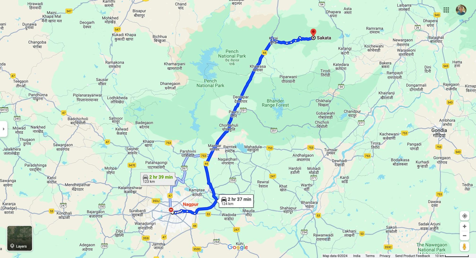
Nagpur is a major metropolitan city connected by rail and airways. To reach the start of the trek, ie., Sakata (camp 1903), you go on NH44 and cover a distance of approximately 125km in 2 and half hours.
Indiahikes arranges pick-up for its trekkers from Nagpur Railway station and Baba Saheb Ambedkar Airport.
1. Here’s a quick view of how to plan your travel
Day 0: Book your air or train ticket to Nagpur. Arrive a day earlier or in the morning.
If you are travelling by flight, you can fly to Nagpur from almost all the major cities like Bangalore, Hyderabad, Mumbai, Delhi, etc.
If you are travelling by train, there are railway connections from Kolkata, Delhi, and other major cities.
Any type of train tickets should be easy to obtain if you book 2-3 weeks before your schedule.
Day 1: Reach Sakata (Camp 1903) and camp for the night.
Pick up for Indiahikes trekkers is at 2:00 PM from Nagpur Railway Station. The contact number of your transport coordinator will be shared a day or two before your departure.
Day 2: Trek from Sakata (camp 1903) to Point 2 (Nalair camp)
Day 3: Trek from Nalair camp to Sawangi Village
Day 4: Trek from Sawangi Village to Rukhad gate. Drive to Nagpur.
2. Planning your return journey
You will arrive at Nagpur at 7pm. You can book train or flight late in the night. We would recommend keeping. a buffer of at least 2-3 hours.
3. If Planning your Hotel/Stay
If you are arriving at Nagpur a day prior or want to explore the city further after your trek, you will find numerous hotel options in the city.
These are documents required for legal purposes by Indiahikes and the forest department. Without any of these, you will not be allowed to trek.
- Original and 2 (two) photocopies of government identity card. Anything such as a driver’s license, Aadhar Card, or passport will do. This is required by the forest department for your identification.
- 2 (two) passport-size photographs. This is required to obtain the trekking permits
- Disclaimer certificate: There are two sections in this. The first part is a personal medical record. The second part is a legal requirement. Download the PDF, read carefully, fill in and sign it. This must be handed over to your Trek Leader during registration at the base camp. – Download disclaimer certificate
- Medical certificate: The medical certificate needs to be filled out by an MBBS doctor, without which the forest department will not issue permissions for your trek. It is also a requirement by Indiahikes – Download medical certificate
Note: Indiahikes has a panel of doctors who can help you with a medical certificate. They are available for online consultation. To get in touch with them, please write to trekmedicalcertificates@gmail.com. They will respond to you within 24 hours.
Consultation fee: Rs 300
PRO TIPS
Keep important documents in a clear plastic cover and slide them into the inner pocket at the back of your backpack. This keeps them from getting wet.
If you’re trekking in the jungles of Pench in monsoon, the temperature during the day will be around 25 to 30°C and, at night the temperature will drop to 17 to 19 degrees or less. You will need to carry a minimum of one warm layer.
The most important task you have on this trek is to protect yourself from mosquitoes. It would be better if you have a cap with mosquito net covering your face. Along with full sleeved shirts. Long trousers are a must and a waterproof socks would be an additional benefit.
Ensure you carry a pair of sandals and a rain jacket.
Bare Necessities:
- Trekking shoes: Carry trekking shoes and not sports shoes. The trail will be slippery in several places and will require shoes with good grip and ankle support. You can watch this video to learn to choose the right trekking shoes.
- Backpack (40-45 litres): A backpack with sturdy straps and a supporting frame. Rain cover for the backpack is essential.
Clothes
On a trek, carry fewer clothes than you would normally need. Do not pack for ‘what if situations’. That will only add to the weight of your backpack and not be used on the trek. Once your clothes get warmed up on a trek, you will not feel like changing. Just maintain personal hygiene.
- One layer of warm clothes: Carry either one padded jacket or one layers of fleece jacket/ sweater.
- Two trek pants: Carry light quick dry trek pants. One trek pant while trekking and an another pant inside the backpack. Denim/jeans and shorts are not suitable for trekking.
- Three full sleeved t-shirts: You will wear one t-shirt while trekking and the rest two t-shirt inside your backpack. Carry light, full-sleeved t-shirts that prevent sunburns on the neck and arms. Let one of these be a dry-fit t-shirt. It will dry quickly in case you are trekking on a rainy day.
- Sandals: Carry sandals on this trek required on day four during the multiple stream crossing. Trekking shoes are required for the forest but have a handy pair of sandals to slip into.
Accessories
- Sunglasses: Sunglasses are recommended but not mandatory.
- Sun Cap: In the jungles, even though there is heavy tree cover, the harsh sun can dehydrate you very quickly. A sun cap comes in handy to prevent the moisture to escape when you are sweating.
- Socks (4 pairs): Your normal cotton/ sport socks are good, but make sure they are all high ankle socks. Waterproof socks are an additional bonus.
- Headlamp/LED torch: Mandatory + extra Batteries.
- Trekking pole: Watch this video to understand why you need a trekking pole.
- Ponchos: In a jungle, unexpected rain is possible at any time, and hence it’s mandatory to carry a poncho/ rain jacket so that you don’t get wet.
Others
- Toiletries: Sunscreen, light towel, toilet paper, toothbrush, toothpaste, hand sanitizer. Do not carry wet wipes since these are not biodegradable. We do not like biodegradable wet wipes because they take a long time to decompose in the mountains. Use toilet paper instead.
- Sanitary waste: Make sure you bring your used sanitary napkins back to the city with you. Carry a zip lock bag to put used napkins. Bring this ziplock bag back with you to the city and do not dispose of sanitary napkins in the mountains.
- Cutlery: Carry a spoon, coffee mug and a lunch box. We insist on trekkers getting their cutlery for hygiene reasons. We do not allow biodegradable or disposable cutlery on our treks.
- Two water bottles: 1 litre each.
- Plastic covers/ dry sacks: While packing, use plastic bags to compartmentalize things and carry a few extra plastic bags for wet clothes.
- Odomos or any other insect repellant
Carry these medicines with you, easily accessible at all times. Do not take any medicine unless you have consulted your trek leader.
- Crocin (Paracetamol) – 6 tablets (fever)
- Norflox TZ – 3 tablets (diarrhoea/ severe GI issue)
- Band-Aid – 4 strips
- ORS – 4 packets
- Volini Spray - aches, & sprains
- Knee Cap (Optional), if you are prone to a knee injury
- Anti Fungal Powder
- Odomos or any other insect repellent
Our trek leaders carry a medical kit with them. If there is an emergency our trek leaders know how to tackle it. Meanwhile, contact your trek leader before consuming any of these medicines listed here.
Pro Tip: We find that these medicines by trekkers are rarely used. But you cannot do away with them. At the end of the trek please donate unused medicines to your trek leader. Some of these medicines get distributed to villages on the trek and some are added to the Indiahikes medical kit.
We recommend jogging as the best routine to get fit for a trek. It works on the same muscles that you use while trekking — your calves, glutes and hamstrings. It helps increase your stamina day by day. It is also an easy routine that does not require any equipment or tools.
Fitness target:
To do this trek comfortably, you must be able to cover 5 km in under 35 minutes. This is the minimum fitness required for this trek.

How to achieve this fitness?
- Start jogging at least 4 days a week
- If you cannot run 5 km immediately, start with 2 km and increase to 5 km over 2-3 weeks.
- Once you’re able to run 5 km, increase your pace day by day.
- Gradually increase your pace and bring it down to 5 km in less than 35 mins.
- You must be able to run 5 km in 35 mins consistently for at least 2 weeks before the trek.
This trek requires at least 6-8 weeks of preparation. The longer, the better. So plan your trek soon and start preparing.
Here's a complete guide to get you trek fit.
Strength training tips:
How to get Fitness Approval from the Indiahikes team:
Every trekker needs fitness approval from the Indiahikes team 20 days before the trek date. Without this, you will not be allowed on the trek.
What to upload?
- A minimum of 3 screenshots of your runs/jogs/walks/cycling
- Monthly summary of your routine
Why fitness matters:
Every trek comes with a set of challenges. Steep ascents and descents, uneven terrain, boulder walks, stream crossings, and summit climb. Even the easiest of treks have some of these challenges if not all of them. Without fitness, trekkers struggle, get injured easily, lag behind, or simply fail to complete the trek.
At Indiahikes, we take pride in the fact that our trekkers are among the fittest in the country. Those who do not meet the fitness requirements are often sent back. Our philosophy is that trekking and fitness go hand in hand. Without fitness, there’s no trekking.
The trek is 4 days long, with 3 days of trekking.
You can go on safaris and other wildlife sightseeing after booking tickets from official government portals. However, no one is allowed to trek inside its jungles on the itinerary mentioned on this trek page yet.
Trekking in a very rich biodiversity hotspot like Pench naturally comes with risks. However, two forest officials who know their area in and out, accompany the group at all times. In its long history as a national Park and a tiger reserve, there has been no reported cases of tigers attacking humans.
One major region being that Pench tiger reserve has of the highest density of herbivores (90.3 animals per square kilometer). Tigers other predators have plenty of food supply. They do not see humans in their food chain.
No, you cannot take a bath on the trek. However, we understand that you give a lot of importance to personal hygiene. Especially while trekking in groups. Here is one video that you can watch to learn how to take a mini-bath!
Clean drinking water will be available at each of the campsites. We recommend carrying 2 litres of water at the start of each day.
Yes, we can. Please inform your designated experience coordinator of any special requests in advance. We have the facility to provide you with special food. We also cater to any food allergies that you might have.
For the very first time in Indiahikes, we do not prohibit offloading on a trail. All the campsites are well connected by mud trails and roads. The designated roads do not disturb the habitat of the park.
Since the trek days and distances are long, we would rather want you to opt for this facility and enjoy the jungles fully.
Yes. We have a cloakroom facility available at the basecamp in Sakata (Camp 1903) for extra luggage. Every trekker is permitted to leave behind one piece of luggage at no charge. Anything beyond one piece of luggage is chargeable at Rs 500 per luggage.
(The luggage could be a backpack / suitcase / duffel bag or anything similar.).
You will get this luggage back on the last day of the trek at Rukhad gate.
The maximum recommended weight of the bag will be 6 to 7 Kilos with two filled water bottles.
Yes, items mentioned in the packing list like sun caps, sunscreen, trek poles, high/mid ankle trek shoes, dry fit pants, and t-shirts are mandatory. If you do not want to buy them, you can rent them out at our rental store here.
Sakata (camp 1903) is well connected by NH44 from Nagpur city. Indiahikes organises pick-up from Nagpur Railway Station as well as Nagpur Airport at 1 pm for the trekkers.
If you miss the Indiahikes pick-up, you can take a cab from the city to Sakata.
The trekkers coming by public bus from Seoni/Jabalpur or Nagpur ca n get down at Kurai (state transport or private buses are quite frequent between these cities). A private cab can be arranged to reach Sakata, which is 20 km away from the highway.
Photo Gallery
Other Treks Like Pench Mowgli Trek
Sign up for our much loved Weekly Mailer
We have terrific trekking tips, trek updates and trek talks to look forward to
Treks by Categories
Contact Us
080 468 01269
Mon to Sat - 9.30 AM to 7.30 PM
Sun - 9.30 AM to 6.30 PM
Bengaluru Office
139, Defence Colony Road, Defence Layout, Sahakar Nagar, Bengaluru, Karnataka 560092
Dehradun Office
Mohabbewala, Titan Road, Near Titan Factory, Chandramani Khalsa Dehradun - 248002
© 2024 Indiahikes Private Limited
All images are copyrighted by their respective authors.
58e7.jpg)
9cbf.jpg)
